Tulum is the site of a Pre-Columbian Maya walled city serving as a major port for Cobá.
Tulum’s greatest attraction is its location itself as it stands on a bluff facing the rising sun looking out on views of the Caribbean that are nothing less than spectacular scenery. Ruins are situated on 12-meter (39 ft) tall cliffs, along the east coast of the Yucatán Peninsula on the Caribbean Sea in the state of Quintana Roo, Mexico.
The Yucatan Peninsula on Mexico’s southeastern coast is famous for its fabulous beaches, Mayan archeological sites, and the Great Mayan Reef. Many visitors come for the sun and nightlife and spend their time in one of the luxurious hotels along the Cancun strip. There’s more to the Yucatan than Cancun and it’s easy to rent a car or hop on a local bus and see it all.
The Yucatan has 500 species of birds. It’s a great place for snorkeling and diving because the second largest coral reef system in the world runs by it.
Tulum is said as one of the last cities inhabited and built by the Mayans, it was at its height between the 13th and 15th centuries and managed to survive about 70 years after the Spanish began occupying Mexico. Now known as one of the best-preserved coastal Maya sites, Tulum is today a popular site for tourists.
Tulum has architecture design typical of Maya sites on the east coast of the Yucatan Peninsula. This architecture is then recognized by a step running around the base of the building which sits on a low substructure similar to Chichen Itza. Doorways of this type are usually narrow with columns used as support if the building is big enough.
As the walls flare out there are usually two sets of molding near the top. The most of the room contains one or two small windows with an altar at the back wall, roofed by either a beam-and-rubble ceiling or being vaulted. This type of architecture resembles what can be found in the nearby Chichen Itza, just on a much smaller scale.
The name Tulum is the name given the site following a visit by the explorers Stephens and Catherwood in 1841, just before the beginning of the Caste War in 1847, long after the city was abandon and fell to ruins.
They ordered trees cleared and Catherwood made illustrations of temples, later to be published in their famous book “Incidents of Travel in Yucatan”. Juan José Gálvez is actually credited with Tulum’s rediscovery in 1840.
Tuesday
Monday
Perito Moreno Glacier
The Perito Moreno Glacier is a glacier located in the Los Glaciares National Park in the south west of Santa Cruz province, Argentina. It is one of the most important tourist attractions in the Argentine Patagonia.
The glacier was named after the Argentinian explorer Francisco Moreno, who was born in 1852. Moreno discovered and explored numerous lakes and rivers in Patagonia and, inspired by America's Yellowstone Park, was instrumental in creating South America's first national park, the Nahuel Huapi National Park.
Perito Moreno Glacier was declared a Natural Heritage of Humanity by UNESCO in 1981.It is also considered the eighth wonder of the world because of the spectacular view it offers.It stands 80 meters (262 ft) tall and is 5 kilometers (3 miles) long.
The Perito Moreno Glaciers in the province of Santa Cruz is without a doubt one of the biggest natural spectacles of the world. Every 3-4 years when the ice breaks, it creates a fantastic natural performance not to be missed..
It is one of 48 glaciers fed by the Southern Patagonian Ice Field located in the Andes system Argerntina shares with Chile. It is the world's third largest reserve of fresh water. Photographers and film crews come from all over the world to Patagonia in southern Argentina to capture the event.
The calving of the Perito Moreno Glacier is one of the most impressive natural phenomena in the world. You can enjoy the thrill of seeing massive chunks of ice plunge forcefully into the water.
Friday
Pantanal
The Pantanal (swamp or marsh in Portuguese) is a region in South America lying mostly in Western Brazil but extending into Bolivia as well. It is considered one of the world's largest and most diverse freshwater wetland ecosystems. The Pantanal is also one of Brazil's major tourist draws, for its wildlife. Some of the large cattle farms offer accommodations and organized tours.
Millions of waterfowl breed along the Pantanal National Park rivers and lagoons of. Dense populations of jaguars, capybara, hyacinth macaws, roseatte spoonbills, jabiru storks, kingfishers, rheas, magnificent Tababeuia trees and others thrive in its forest and grasslands. The Pantanal attracts dense populations of animals that feed and breed along its waterways, including giant river otters, river dophins, marsh deer and tapirs.
The wetland also provides habitat for more than 650 bird species, including cormorants, egrets, herons, ibis, jabiru storks and roseate spoonbills. Less than 2 per cent of the Pantanal is under federal protection. The strategic location of Pantanal makes it more vulnerable to the advance of large scale agriculture, cattle ranching, water pollution, dams and transport navigation, thereby increasing the pressure on the local habitats. Funds go directly to manage, monitor and restore this vast 400,000-acre watershed, critical habitat for migrating animals during the rainy season.
CLIMATE: Usually warm to very hot and dry throughout, but occasionally winter cold fronts push up from the south bringing cooler weather and some rain.
DIFFICULTY: Mostly easy and flat. There is one steeper and more difficult optional hike at Cristalino.
Sunday
Actun Tunichil Muknal
This is the acclaimed “Cave of the Crystal Maiden,” one of the most spectacular natural and archaeological attractions in Central America. The trip to Actun Tunichil Muknal, or ATM, as the cave is also known, is for fit and active people who do not mind getting wet and muddy—and who are able to tread lightly around ancient artifacts.
Just about 1-1/2 hrs drive southeast of San Ignacio we arrive at the car park where we reorganize for a 45 minute hike through the jungle with three knee-high river crossings on the hike to the cave entrance.
The cave has a rich archeological history of the Ancient Maya, with dates of activity recorded from the Classic Period of 200AD to the Late Classic of 900AD.
Actun Tunichil Muknal cave was used by the Late-Classic Maya as a place for sacrifice. The cave’s sacrificial room is a broad raised area reachable only by wading and swimming the underground river back for about a mile then climbing a large rock to step across to a ledge near the ceiling.
As with any cave exploring, one can only think of where to put one’s foot so as not to slip and which rock to grab when falling to avoid the sharp ones.
Around the edges of this large space are many offerings containing human skulls and pots of different shapes and sizes.
Lying undisturbed for a thousand years the bones and pottery are covered with waterborne calcite.The Maya had many ways to solicit the spirits. One method of sacrifice was to remove the lower jaw while the victim was still alive which, it is said, makes the eyes pop out.
There is evidence elsewhere of this procedure carved in stone as well as in paintings on ceramics. The lower jaw is missing on most of these skulls. Another way to sacrifice is face flaying but this may not have been done at the same time as jaw removal as the victim would already be dead.
The History of ATM
Actun Tunichil Muknal was discovered in 1989 and opened to the public in 1998. Dr. Jaime Awe, a Belizean archaeologist was the first to explore the cave. Dr. Awe and his Western Belize Regional Cave Project (WBRCP) conducted archaeological research at Actun Tunichil Muknal from 1993-2000.
In January of 2003, it was decided that 455 acres of the Tapir Mountain Nature Reserve would be re-designated as a natural monument. Official signing of the Memorandum of Understanding between the Belize Audubon Society and the Institute of Archaeology (IoA) occurred on June 10, 2004. This agreement was the first of its kind to be signed by the Society for the co-management of an archeological site.
Getting There
Actun Tunichil Muknal Natural Monument is located south of Teakettle Village in the Cayo District. The junction is at mile 52 on the Western Highway. Due to the sensitive nature of this cave only two tour companies are licensed to take guests here: Pacz Tours and Mayawalk Tours, which are based in San Ignacio. Tickets must be purchased in advance.
Thursday
Steinsdalsfossen famous waterfall in Norway
Steinsdalsfossen waterfall is one of Norway's best waterfalls and already famous in the world, its height reached 50 meters, is located 2 kilometers east of Norheimsund. Steinsdalsfossen waterfall is one of the most visited attractions in Norway. have the road behind him that allows visitors to take a closer look. For those of you who like the waterfall, if you come to Norway please stop by this waterfall.
Natural beauty of the Yunnan Stone Forest, China
The Yunnan Stone Forest is located in Kunming, which serves as the capital of the Yu The Stone Forest Scenic Area is located in Shilin County, 89 kilometers from Kunming. The area, covering 350 square kilometers, is the highest karst terrain in the world and a national scenic area in China. In the scenic area one can see stone forest, known as “No. 1 wonder under heaven.” The Sani people, a branch of the Yi ethnic group, live in the area.
The beauty of the famous Yellowstone National Park, USA
One of best tourism places in United States is The Yellowstone National Park. It is the largest geothermal in the world. The whole of the park is caldera, a volcanic crater with molten rock a mere three miles below the surface. The park is located at the headwaters of Yellowstone River. Yellowstone National Park has area 3468 square miles comprising lakes, canyon, river and mountain range.
Wednesday
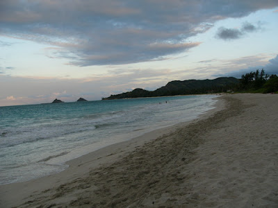
Famous Kailua beach in Hawaii, United States
Hawaii is very famous for its beautiful beaches and many places of interest. One of the popular beaches in Hawaii are Kailua Beach. Many people say the beach is the most beautiful beaches in the world. The beach is located on the southeastern island of Oahu, Kailua. Kailua Beach is a very well known by the white sand. for those of you who will travel to the United States, take a moment to enjoy the beautiful beaches of this pristine Kailua.
Arenal Volcano National Park is famous in costa rica
Arenal Volcano National Park is one of the famous national parks in Costa Rica. It is home to the famous mountain named Arenal Volcano, the most active mountain in the country. For a long time volcanic lava issued regularly, it makes a crater opened. This is an active volcano that has a height of about 1.633 meters had stopped to spew lava in 2010, allowing audiences to see the mountain near. In addition to the home to the most active volcanoes in Costa Rica, the national park also has a volcano that is Mt Chato others who have experienced the last eruption about 5,000 years ago. With an area of approximately 2.040 square kilometers, Arenal Volcano National Park offers several nature tours. The visitors will be interested in wildlife and natural wonders in this park. For wildlife, there are 4.00 species of birds, reptiles, mammals and other endangered animals such as Jaguar, Tapir Howler Monkey and Bird. In addition to volcanoes, other natural wonders that you can see in the Arenal Lake Arenal Volcano National Park, waterfalls, hiking trails and hot springs. Arenal volcano is very pampering for those of you who like to climb the mountain, so please feel free to enjoy the beauty of the Arenal volcano to increase your love of natural beauty.
Samara most beautiful beaches in Costa Rica
Country Costa Rica has many interesting natural attractions, but there is one must-see sights are the beaches of Samara. This beach is located on the Nicoya Peninsula in Costa Rica's Pacific Coast. Samara beach stretches about 6 kilometers in length and is completed by many tourists, but very quiet at night. Samara beach is categorized as a flat beach, you can enjoy the vast beauty of Samara beach because the beach is flat with a beautiful white sand and excellent water quality. For those of you who like to surf, dive or swim in Samara this beach provides good facilities for Samara on Kalim beach as a safe beach in the country of Costa Rica.
Monday
The beauty of the river Krka national park
The beauty of the river Krka national park has been recognized, national park Krka is situated country of Croatia. Krka National Park was established in 1985, 142 sq km Krka National Park Krka river follow the line, from its source in the foothills of the Dinaric karst short journey through the dramatic landscape to settle in the Adriatic. The river flows through a limestone canyon, dropping more than 220m in 50km, with eight sets of rapids.
Saturday
Mt. Vesuvius
Vesuvius is one of the best-known volcanoes in the world and is arguably Europe’s most dangerous volcano.
Mt. Vesuvius is still active today. It is the only active volcano on the European mainland.
Mt. Vesuvius's most famous eruption was in 79 A.D. when it destroyed the citites of Herculaneum and Pompeii. When Vesuvius erupted it covered the cities of Herculaneum and Pompeii it covered the cities with 20 feet of volcanic debris.
During this eruption about 2000 people were killed inculding Pliny the Elder, a Roman naturalist. That eruption was called a plinian explosion. This means that when extremely gas-rich, viscous magma explodes deep inside a volcano (the vent serves as a gun barrel) and tremendous blast shoots straight up at twice the speed of sound, creating a vertical column of ash as much as 20-miles high. Since then it has erupted over 50 times and is still active.
Some other eruptions include one in 1631 when 5 towns were destroyed and 3000 people were killed, another one was in 1794 when it destroyed the town of Torre Del Greco.The next viloent eruption happenned on April 1906 when it lasted ten days and causing great destruction and killed 2000 people. Since then smaller eruptions happenned in 1913, 1926, 1929, and 1944.
Subscribe to:
Posts (Atom)