Showing posts with label America. Show all posts

Tuesday

Tulum of Yucatan Peninsula of Mexico

Tulum is the site of a Pre-Columbian Maya walled city serving as a major port for Cobá.
Tulum’s greatest attraction is its location itself as it stands on a bluff facing the rising sun looking out on views of the Caribbean that are nothing less than spectacular scenery. Ruins are situated on 12-meter (39 ft) tall cliffs, along the east coast of the Yucatán Peninsula on the Caribbean Sea in the state of Quintana Roo, Mexico.
The Yucatan Peninsula on Mexico’s southeastern coast is famous for its fabulous beaches, Mayan archeological sites, and the Great Mayan Reef. Many visitors come for the sun and nightlife and spend their time in one of the luxurious hotels along the Cancun strip. There’s more to the Yucatan than Cancun and it’s easy to rent a car or hop on a local bus and see it all.

The Yucatan has 500 species of birds. It’s a great place for snorkeling and diving because the second largest coral reef system in the world runs by it.
Tulum is said as one of the last cities inhabited and built by the Mayans, it was at its height between the 13th and 15th centuries and managed to survive about 70 years after the Spanish began occupying Mexico. Now known as one of the best-preserved coastal Maya sites, Tulum is today a popular site for tourists.

Tulum has architecture design typical of Maya sites on the east coast of the Yucatan Peninsula. This architecture is then recognized by a step running around the base of the building which sits on a low substructure similar to Chichen Itza. Doorways of this type are usually narrow with columns used as support if the building is big enough.

As the walls flare out there are usually two sets of molding near the top. The most of the room contains one or two small windows with an altar at the back wall, roofed by either a beam-and-rubble ceiling or being vaulted. This type of architecture resembles what can be found in the nearby Chichen Itza, just on a much smaller scale.

The name Tulum is the name given the site following a visit by the explorers Stephens and Catherwood in 1841, just before the beginning of the Caste War in 1847, long after the city was abandon and fell to ruins.

They ordered trees cleared and Catherwood made illustrations of temples, later to be published in their famous book “Incidents of Travel in Yucatan”. Juan José Gálvez is actually credited with Tulum’s rediscovery in 1840.

Monday

Perito Moreno Glacier

The Perito Moreno Glacier is a glacier located in the Los Glaciares National Park in the south west of Santa Cruz province, Argentina. It is one of the most important tourist attractions in the Argentine Patagonia.

The glacier was named after the Argentinian explorer Francisco Moreno, who was born in 1852. Moreno discovered and explored numerous lakes and rivers in Patagonia and, inspired by America's Yellowstone Park, was instrumental in creating South America's first national park, the Nahuel Huapi National Park.

Perito Moreno Glacier was declared a Natural Heritage of Humanity by UNESCO in 1981.It is also considered the eighth wonder of the world because of the spectacular view it offers.It stands 80 meters (262 ft) tall and is 5 kilometers (3 miles) long.

The Perito Moreno Glaciers in the province of Santa Cruz is without a doubt one of the biggest natural spectacles of the world. Every 3-4 years when the ice breaks, it creates a fantastic natural performance not to be missed..
It is one of 48 glaciers fed by the Southern Patagonian Ice Field located in the Andes system Argerntina shares with Chile. It is the world's third largest reserve of fresh water. Photographers and film crews come from all over the world to Patagonia in southern Argentina to capture the event.

The calving of the Perito Moreno Glacier is one of the most impressive natural phenomena in the world. You can enjoy the thrill of seeing massive chunks of ice plunge forcefully into the water.

Friday

Pantanal

 The Pantanal (swamp or marsh in Portuguese) is a region in South America lying mostly in Western Brazil but extending into Bolivia as well. It is considered one of the world's largest and most diverse freshwater wetland ecosystems. The Pantanal is also one of Brazil's major tourist draws, for its wildlife. Some of the large cattle farms offer accommodations and organized tours.

Millions of waterfowl breed along the Pantanal National Park rivers and lagoons of. Dense populations of jaguars, capybara, hyacinth macaws, roseatte spoonbills, jabiru storks, kingfishers, rheas, magnificent Tababeuia trees and others thrive in its forest and grasslands. The Pantanal attracts dense populations of animals that feed and breed along its waterways, including giant river otters, river dophins, marsh deer and tapirs.

The wetland also provides habitat for more than 650 bird species, including cormorants, egrets, herons, ibis, jabiru storks and roseate spoonbills. Less than 2 per cent of the Pantanal is under federal protection. The strategic location of Pantanal makes it more vulnerable to the advance of large scale agriculture, cattle ranching, water pollution, dams and transport navigation, thereby increasing the pressure on the local habitats. Funds go directly to manage, monitor and restore this vast 400,000-acre watershed, critical habitat for migrating animals during the rainy season.
CLIMATE: Usually warm to very hot and dry throughout, but occasionally winter cold fronts push up from the south bringing cooler weather and some rain.
DIFFICULTY: Mostly easy and flat. There is one steeper and more difficult optional hike at Cristalino.

Sunday

Actun Tunichil Muknal

This is the acclaimed “Cave of the Crystal Maiden,” one of the most spectacular natural and archaeological attractions in Central America. The trip to Actun Tunichil Muknal, or ATM, as the cave is also known, is for fit and active people who do not mind getting wet and muddy—and who are able to tread lightly around ancient artifacts.

Just about 1-1/2 hrs drive southeast of San Ignacio we arrive at the car park where we reorganize for a 45 minute hike through the jungle with three knee-high river crossings on the hike to the cave entrance.

The cave has a rich archeological history of the Ancient Maya, with dates of activity recorded from the Classic Period of 200AD to the Late Classic of 900AD.

Actun Tunichil Muknal cave was used by the Late-Classic Maya as a place for sacrifice. The cave’s sacrificial room is a broad raised area reachable only by wading and swimming the underground river back for about a mile then climbing a large rock to step across to a ledge near the ceiling.

As with any cave exploring, one can only think of where to put one’s foot so as not to slip and which rock to grab when falling to avoid the sharp ones.

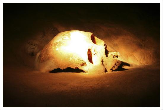
Around the edges of this large space are many offerings containing human skulls and pots of different shapes and sizes.

Lying undisturbed for a thousand years the bones and pottery are covered with waterborne calcite.The Maya had many ways to solicit the spirits. One method of sacrifice was to remove the lower jaw while the victim was still alive which, it is said, makes the eyes pop out.
There is evidence elsewhere of this procedure carved in stone as well as in paintings on ceramics. The lower jaw is missing on most of these skulls. Another way to sacrifice is face flaying but this may not have been done at the same time as jaw removal as the victim would already be dead.


The History of ATM

Actun Tunichil Muknal was discovered in 1989 and opened to the public in 1998. Dr. Jaime Awe, a Belizean archaeologist was the first to explore the cave. Dr. Awe and his Western Belize Regional Cave Project (WBRCP) conducted archaeological research at Actun Tunichil Muknal from 1993-2000.

In January of 2003, it was decided that 455 acres of the Tapir Mountain Nature Reserve would be re-designated as a natural monument. Official signing of the Memorandum of Understanding between the Belize Audubon Society and the Institute of Archaeology (IoA) occurred on June 10, 2004. This agreement was the first of its kind to be signed by the Society for the co-management of an archeological site.

Getting There

Actun Tunichil Muknal Natural Monument is located south of Teakettle Village in the Cayo District. The junction is at mile 52 on the Western Highway. Due to the sensitive nature of this cave only two tour companies are licensed to take guests here: Pacz Tours and Mayawalk Tours, which are based in San Ignacio. Tickets must be purchased in advance.

Tuesday

Cordillera Del Paine

Mountains are considered to be one of the most magical out of all nature’s delights. They have a unique and rare charm to them that combine beauty with adventure. Besides mountains are also said to be symbolic of being perseverant and dedicated to achieve all goals set in life. A perfect example to all this is the Cordillera del Paine in Chile.

Torres del Paine National Park is a large park of 2,400 km² and a popular trekking destination with a large number of mountains, lakes and rivers, and biodiversity from sub-polar forests to coastal desert.

The best-known and most spectacular summits are the three Towers 
of Paine. They are gigantic granite monoliths shaped by the forces of glacial ice. Other summits include the Cuerno Principal, about 2,100 m but often quoted at 2,600 m, and Cerro Paine Chico, which is usually correctly quoted at about 2,650 m.

The Cordillera del Paine Mountains that belong to the Andes form the core of the park. The national park was founded in 1959 and renamed Torres del Paine in 1970. It was granted a UNESCO World Biosphere Reserve status in 1978 and today, Torres del Paine National Park is a popular outdoor activity destination with good basic services for visitors.

Torres means "towers" and paine means "blue," a reference to the blue hue of the park's glacial lakes and its four main glaciers, which are connected to the Southern Patagonia Icefield. The city of Punta Arenas, a four-hour flight from Santiago, serves as the central Torres del Paine hub. From there, catch a three-hour bus ride to Puerto Natales and then let your interests dictate the way you access the park, from the luxe (sailing) to the DIY (hopping another bus to one of the three entrances).

Safety & restrictions
Torres del Paine is a safe destination with no crime problems, but the extreme weather conditions can cause danger. Hikers in the national park should always stay on paths and camp in designated areas only. Wood fires are prohibited because of the big risk of forest fires.

Sunday

Iguazu Falls

Iguazu Falls (also called Iguacu Falls) are known throughout the world as one of the most beautiful and majestic natural waterfalls man has ever seen. The falls themselves sit on the Iguazu River and rest on the border between Brazil and Argentina. Visited by many people every year, the Iguazu Falls are one of the more popular natural tourist destinations in South America.

The falls themselves sit on the Iguazu River and rest on the border between Brazil and Argentina. Visited by many people every year, the Iguazu Falls are one of the more popular natural tourist destinations in South America.

Iguazu Falls, in the Iguazu River, is one of the largest waterfalls in the world and a tremendous natural wonder being that there are about 275 separate waterfalls ranging from 200 – 269 feet high

The name Iguazu simply means "great waters" in the local Indian language. According to legend, the great waterfall was created in an outburst of rage by the god of the Iguazu River, who lived in a particularly wild and violent area of the downpour called the Garganta del Diablo (Devil's Throat). The Falls are close to the point where the Iguazu and the Parana rivers join and the boundaries of Brazil, Argentina, and Paraguay converge. The countries are linked by two bridges: the Amistad (Friendship) Bridge between Brazil and Paraguay, and the Tancredo Neves Bridge between Brazil and Argentina.

When to go
March to November is frequently considered the best time to visit the Iguassu Falls. But, in reality, there isn’t a best time. It depends on what you value most.

The high season is in January and February, when most Brazilians and Argentineans are in holidays. For those who want to experience the splendour and the impressiveness, that’s a good period to visit the Iguassu Falls. But… there are some downsides. The sky is bluer (it’s the peak of the summer) and the volume of the waters is high, but the humidity and the heat are also at their highest levels (as are the hotels prices and their occupation). And this is also a crowded period, you might wish to avoid.

If you want to avoid crowded periods, avoid the Easter time also. There is a strong Brazilian and Argentinean tradition to visit the Iguassu Falls in Easter. Vast throngs of tourists invade the place in Easter, crushing the quietness of most of the year. If you want to bet on low hotel prices, this is not a good season, either.

May and July are rainy months and the volume of the waters is at its maximum. The rain is rarely a problem, except for those who are looking for a quick day visit. In that case, the rain may strike the unfortunates.

If you want to enjoy an agreeable temperature, lower prices, less people and a very low probability of a troubling rainy day, September and October are great months. But it all depends of your style and preferences – and possibilities...

Friday

Grand Canyon of Arizona


The Grand Canyon of the Colorado River in northwestern Arizona is one of the earth's greatest natural wonders. It became a national park in 1919. So famous is this landmark to modern Americans that it seems surprising that it took more than thirty years for it to become a national park.

The Grand Canyon, created by the Colorado River over a period of 6 million years, is 446 km long, ranges in width from 6 to 29 km and attains a depth of more than 1.6 km. During prehistory, the area was inhabited by Native Americans who built settlements within the canyon and its many caves.

Although not the steepest nor the longest canyon in the world, the Grand Canyon is recognized as a natural wonder because of the overall scale and size combined with the beautifully colored landscape. The canyon offers a variety of lookouts and experiences that provide visitors with a view that cannot be matched.

Best Ways to See the Grand Canyon

Many spectacular views of the Grand Canyon can be experienced from the many vistas that are presented throughout the park, particularly along the South Rim. However, probably the most spectacular view of the canyon occurs from the Toroweap Overlook. The only challenge is that this view is only accessible by three different dirt paths:

-St. George, Utah (97 miles)
-Colorado City (62 miles)
-Pipe Spring National Monument (64 miles)


An easier alternative to a still breath taking view can be experienced through Lipan Point on the South Rim. This view exposes visitors to a variety of rock strata and delivers an amazing view of the Unkar Creek area.

A helicopter tour is the best way to truly appreciate the vastness of the canyon.

The best times to explore the Grand Canyon could easily be debated. Winter scenes are arguably some of the most spectacular scenes, however the winter months close the roads to the North Rim which really provide the better views of the vastness of canyon.

With that said, the best time to explore the Grand Canyon is during the summer months which provide visitors with greater access to a variety of opportunities that the Grand Canyon provides to explorers. If you really want to explore the Grand Canyon, don’t plan a day trip. One could easily consume a week discovering and exploring the canyon.

Bay of Fundy

The Bay of Fundy (French: Baie de Fundy) is located on the Atlantic Ocean coastline of North America, at the northeast end of the Gulf of Maine between the Canadian provinces of New Brunswick and Nova Scotia. A small portion of the bay touches the northeast corner of the state of Maine.

The tides in Canada's Bay of Fundy are the most extreme in the world. Because of the unique shape of the bay, the difference in water level between high tide and low tide can be as much as 48 feet (14 meters). Observing tidal changes over time at any coastal location can show interesting patterns. These patterns can reveal the relationship between tides and the lunar cycle. Bay of Fundy is also popular for their rocks that are as high as four storey building.

Twice everyday the Bay of Fundy fills and empties of its 100 billion tonnes of water, creating the highest tides in the world. The height of the tide is 3.5 meters (11ft) along the southwest shore of Nova Scotia and steadily increases as the flood waters travel up the 280 km (174 miles) of shoreline to the head of the Bay where in the Minas Basin the height of the tide can reach 16 meters (53ft).


The force created by these mighty waters is equal to 8000 locomotives or 25 million horses at the Minas Channel. This energy works within the Bay’s waters to stir up nutrients from the ocean floor, the mud flats and salt water marshes providing an abundance of food for the birds, whales, fish and bottom dwellers that visit or call Fundy home.

Because by its amazing, it is not surprising if Bay of Fundy become the finalist of New 7 Wonders of Nature. Fish, lobster, mussel, scallops, smoked salmon are several foods that you can eat in the Bay of Fundy. Winter is one of the best times to explore the Bay of Fundy, you will be impressed by two-tone seascapes, random ice cakes, frothy of snow and swirling winds.

Thursday

Crystal Cave of Bermuda

 Crystal caves in Bermuda is about 120 feet under the ground and is one of the largest caves in Bermuda. The caves are the most famous of many subterranean caves in Bermuda and are located in Hamilton Parish, close to Castle Harbor.

The clarity is so perfect that it is possible to see the cave floor, which at one point lies 55 feet below the deep blue underground Cahow Lake. The cave features a variety of formations that include: soda straws and stalactites. However, some crystal formations have been damaged by earthquakes in the far past.

Crystal is the most famous and visited cave in Bermuda. It's believed to have been discovered by two 14-year-old boys in 1905 when they went looking for their lost ball. Instead of going down via 140 feet of strong rope tied to a tree like they did, you can walk down 83 steps to view the magnificent crystal stalactites and stalagmites. You can only touch two broken-off crystals because they take hundreds of years to grow.

In fact, they grow only a cubic inch every century. Crystal cave is 1.6 million years old and that's considered young. Down below you can explore the crystals along a wooden floating pontoon walkway that sits on top of a clear 55-foot-deep lake.

The Crystal Caves Bermuda is owned by the Wilkinson family since 1884. It has been dubbed “ Crystal” because of the crystal clear blue pool of water that occupies it.

Indeed, the water is so clear that its transparency offers a view of the cave floor. In certain points, the cave has a depth of 55 feet below the water surface. Adorning the caves are numerous stalactites and stalagmites formed over several million years.

Tuesday

Angel Falls

Angel Falls or Salto Angel is the world's highest free-falling waterfall at 978 metres (3,212 feet) with an uninterrupted drop of 807 metres (2,647 feet). It is located on an unnamed tributary of the Rio Caroni, in the Canaima National Park, Venezuela.

Angel Falls-the world's tallest waterfall-is one of the eight natural wonders of the world. You are there, after a long, hot hike, swimming in one of the refreshing natural pools beneath the towering falls.

The waterfall can only be easily seen from across the gorge, from several hundred feet away, and even after a good rain the night before, there was not much water going over the cliff. The falls also faces north, which makes for some difficult lighting on a sunny day.

You look up and see a rainbow created from the dance of the mist and the tropical sun. As you swim in the clear waters with your traveling companions, you sense a spiritual force, a mysterious energy that soothes you. You lean back and float in the natural pool and realize that you are far way from everything, but there is no other place that you would rather be.

Although first sighted in the early 20th century by the explorer Ernesto de Santa Cruz, the waterfall was not known to the world until its official discovery by the American aviator, James Crawford Angel, on a flight whilst searching for gold. Angel was born in Springfield, Missouri in 1899. The falls are currently named "Angel Falls" after him; interestingly enough, the indigenous name for the falls was "Devil's Mouth".

The official height was determined by a National Geographic Society survey in 1949 (see Jungle Journey to the World's Highest Waterfall by Ruth Robertson). David Mott's book, Angels Four, chronicles the first successful climb up the face of Auyan Tepui (Devil's Mountain) to the top of the falls. The falls are one of Venezuela's top tourist attractions.


Getting There:
Air:

As stated, access to Canaima National Park is by air to the village of Canaima, about 50 km away from the falls. From there, you take either a smaller plane and fly to an airstrip at Canaima Lagoon, or travel by river to the lagoon. From the lagoon, you hike to a view point of the falls.

There are also daily flights via Puerto Ordaz connecting Canaima airstrip with the major cities of Venezuela. The airstrip is a short jeep-train ride from nearby Lodges. Check flights from your area to Caracas or other Venezuelan cities with connections to Ciudad Bolicar and Canaima. From this page, you can also browse hotels, rental cars, and special deals.

Water:

From Canaima, when the water is neither too high or too low, you can travel by motorized canoe, called curiara up the Carrao River, then the Churun river to an point where you can then hike through the jungle to the falls. The river portion takes about four hours, and you should allow an hour or more for the hike. Canoe access to Angel Falls is restricted to the rainy season, June to November.

When to Go:
Any time of year. However, the falls depend on rainfall, so in dry season, between December and April, the falls are less spectacular. During the rest of the year, with greater rainfall, the falls are heavier, but clouds often obscure the top of the Auyantepui.

The climate of the great savanna plateau is temperate with a mean annual temperature of 24.5° C with the temperatures on tepui summits as low as 0° C during the night.


ark, Venezuela.

Peruvian Amazon

 The Peruvian Amazon, the fourth largest expanse of tropical rainforest in the world, is home to thousands of indigenous peoples speaking dozens of languages, including some of the last groups living with little or no direct contact with the outside world.

Peru is classified as an Andean country, yet the Amazon jungle takes up more than 60% of the country. And its reach was once far greater, between 13-16% of the total size of the Amazon. During colonial times, the viceroyalty of Peru continued to lose land with the advance of the Portuguese, resulting in the treaties of Tordesillas and San lldefonso. The creation of new regions, such as New Granada and Río de la Plata, also affected the size of the Peruvian Amazon. Further territory was lost during wars fought against Gran Colombia, Colombia and Ecuador. A further blow was dealt during the Acre war, between Brazil and Bolivia, in which Peru’s borders were moved, violating terms set out in the earlier treaties.

Despite the large presence of the Amazon, only 13% of Peruvians live there, while 30% of Peruvians live in Lima, on the coast. A large percentage of the Peruvian population are descendants from more than 60 existing Amazon ethnicities, speaking a range of languages, yet for the large majority, the Peruvian Amazon is an unknown and exotic place.

The Peruvian Amazon is traditionally divided into two distinct ecoregions:
The lowland jungle (in Spanish Selva Baja) is also known as Omagua region, Walla, Anti, Amazonian rainforest or Amazon basin. This ecoregion is the largest of Peru, standing between 80 and 1000 meters above sea level. It has very warm weather with an average temperature of 28°C, high relative humidity (over 75%) and yearly rainfall of approximately 103 in. Its soils are very heterogeneous but almost all have river origins, and due to high temperatures and high rainfall they are poor soils with few nutrients.

It contains long and powerful rivers such as the Apurimac, Mantaro, Amazon, Urubamba, Ucayali, Huallaga, Marañón, Putumayo, Yavarí, Napo, Pastaza, Madre de Dios, Manu, Purus, Yurua and rio Tigre. The Apurimac River is the Amazon River’s greatest contributor.

The highland jungle (in Spanish Selva Alta) is also called Rupa-Rupa region, andean jungle, ceja de selva. This ecoregion extends into the eastern foothills of the Andes, between 1000 to 3800 m above the sea level. The eastern slopes of the Andes are home to a great variety of fauna and flora due to the different altitudes and climates within the region. Temperatures are warm in the lowlands and colder in higher altitudes. There are many endemic fauna because of the isolation caused by the rugged terrain of this area.

Monday

Niagara Falls

 The Niagara Falls are located on the border between Canada and the USA, about 100 km south of Toronto. Also often referred to as the honeymoon capital. It has been the backdrop to many honeymoons, proposals, daredevil stunts, and even key moments in the history of the United States

It is also one of the most popular vacation destinations in the country. People come from all over the world to see Niagara Falls (or simply the Falls as they are sometimes referred) to. They are one of the natural wonders of the world. One look at the mesmerizing and cascading waters and you will know why. Both the sight and the thunderous sound of the water falling will bring you under the spell of these magical falls found in central Canada.

Niagara Falls is also the largest waterfall (by volume) in North America. The falls actually consists of three separate components - Horseshoe Falls, American Falls, and Bridal Veil Falls. Combined, the falls has an average discharge of a mind boggling over 7000 cubic meters per second. Over 90% of the volume is over the Horseshoe Falls.

The falls contributes a large amount of hydroelectric power to the power grid in the Eastern US and Canada. In fact, there's a statue of Nikola Tesla at the falls, who was the first to successfully turn the energy of falling water from Niagara Falls into electricity that was distributed for private and industrial use.

Though hydroelectricity has been controversial in terms of the environment (and especially a bane for waterfalling), there's no denying the critical role it has played in allowing certain cities (and even whole economies) to be built up and thrive. The human intervention has also meant the flow of the Niagara River has been regulated in a way that actually slows down the erosion of the falls and improves flood control.
beautiful waterfalls images,beautiful waterfalls, fountains,home waterfalls, waterfalls for home,natural beauty photos,water falls, iceland falls, waterfalls, top waterfalls beautiful waterfalls images,beautiful waterfalls, fountains,home waterfalls, waterfalls for home,natural beauty photos,water falls, iceland falls, waterfalls, top waterfalls